I can remember a time when shade never entered my mind. I ran through the summer of 1980, a year so hot that cars would stop and watch me run, the people inside with their mouths open in amazement. I wondered then what all the fuss was about. Now I know. But those days are long gone.
In my mind, I had mapped out a route that involved Grand Blvd, East Adams, and East Monroe. That is as much shade as you can find in Greenwood and still move. But I was also thinking of a run out Humphrey Highway and off on a side road. I wanted to find a way to get on the Pelucia Creek levee (the north side), east of the highway.
After scourering Google Maps for hours, I found one. At least the map showed one. But I have learned to be suspicious of maps, especially Google Maps. First, the old Mississippi State Road Maps had several significant innacuracies. When I was in my bicycle riding craze phase, I spend many a Friday trying to find roads that did not exist. And on Google Maps, I long ago learned that every turnrow that every existed is on there. Some turnrows are permanent and some are not. Even the ones that are not are on Google Maps. I have learned that one the hard way.
The route I found on my computer stemmed from a road that peels off Humphrey Highway to the east and winds through the county and alledgedly goes up the side of the levee and mile or two off the highway. Why was this something I am interested in? Right off the highway, the north levee has a gate and some threatening verbage on some signs. I have run the other side, and the levee on the west side of the highway, I have run both sides. I want to run the north levee from the highway to the Carroll County hills.
So I decided to scrap my shade plans and do an adventure run out there looking for a way to the levee that skirts the gates and threats. To attempt to deal with the heat, I left running from the Hideout at 6:37 a.m. It was much cooler then, but of course it heated up. I made my way through town, across Highway 82, and out Humphrey Highway. Then I hit made the turn onto County Road 166, commonly known as Mitchel Road. I had been on that road once, about forty-plus years ago. Charlie Turner and I once went hunting somewhere out there.
The road is chip seal for about a mile or two, then turns gravel and slowly loses its rocks. I saw some pretty sights: ditches, wildflowers, a deer, woods, crops, and space. The sense of space that I sometimes get when adventure running rural delta can be amazing. Eventually, the gravel road became a lightly travelled turnrow that ended in a soybean field. I could not even see the levee. I did see a row of trees a hundred meters or more beyond where the turnrow ended. There was a gate on the row which experience has taught me probably followed a ditch. Should I walk through the field over that and cross the gate?
Since I was already tresspassing, I decided that walking across and field and crossing a gate was more tresspassing than most landowners would tolerate. I turned in defeat and headed back the way I came. I was miles and miles without an square inch of shade. By then it was very hot.
Slowly I shuffled back towards the highway eventually finding a patch of shade. I stopped, took my cap off, and stood there panting for a while. Back on the highway, I had a bit over a mile to 82 and then onto Bowie Lane. At that point, I wasn't having fun anymore and just wanted to be home. Finally I got there. I had survived another day of trying to run long in the summer. I had covered 14.55 miles, 9.15 of which were running. The rest were spent walking in an attempt to control my body temperature which is not easy to do when the dew point is 77.
 |
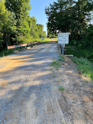
| A scenic overlook along my Friday frolic. You can pull off here and gaze into the ditch three feet below. I heard that someone once took a picture of a turtle from the overlook. Amazing. |
Next week, Penny and I plan to be on the road gong on a mini trip. But the Friday after that will find me somewhere trying to run long. I might have to do the shade route, however, because these heat indexes of 110 plus are getting really old. It's not 1980, but I'm not 24 anymore either. Heck, I'm 66 but too stuborn to quit. Praise God. Sometimes stubborness is a good thing.


No comments:
Post a Comment